


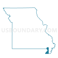
Sunnyvale Voting District, Dunklin County, Missouri
About
Outline

Summary
| Unique Area Identifier | 607754 |
| Name | Sunnyvale Voting District |
| County | Dunklin County |
| State | Missouri |
| Area (square miles) | 13.72 |
| Land Area (square miles) | 13.66 |
| Water Area (square miles) | 0.06 |
| % of Land Area | 99.54 |
| % of Water Area | 0.46 |
| Latitude of the Internal Point | 36.59641310 |
| Longtitude of the Internal Point | -90.05548870 |
Maps


Graphs
Select a template below for downloading or customizing gragh for Sunnyvale Voting District, Dunklin County, Missouri


Neighbors
Neighoring Voting District (by Name) Neighboring Voting District on the Map
- Bernie Rural Voting District, Stoddard County, MO
- Campbell Ward 2 & Rural, Dunklin County, MO
- Glennonville Voting District, Dunklin County, MO
- Malden Ward 3 & Rural, Dunklin County, MO
Top 10 Neighboring County Subdivision (by Population) Neighboring County Subdivision on the Map
- Liberty township, Stoddard County, MO (14,738)
- Cotton Hill township, Dunklin County, MO (5,755)
- Union township, Dunklin County, MO (4,168)
Top 10 Neighboring Unified School District (by Population) Neighboring Unified School District on the Map
- Malden R-I School District, MO (6,275)
- Campbell R-II School District, MO (3,611)
- Bernie School District, MO (3,151)